Traducción automática: Este texto ha sido traducido automáticamente y puede contener imprecisiones. En caso de duda, consulte la versión en inglés.
Gliders and Satellites team up to unveil Zooplankton Hotspots for sustainable Norwegian fisheries

Gliders and Satellites team up to unveil Zooplankton Hotspots for sustainable Norwegian fisheries

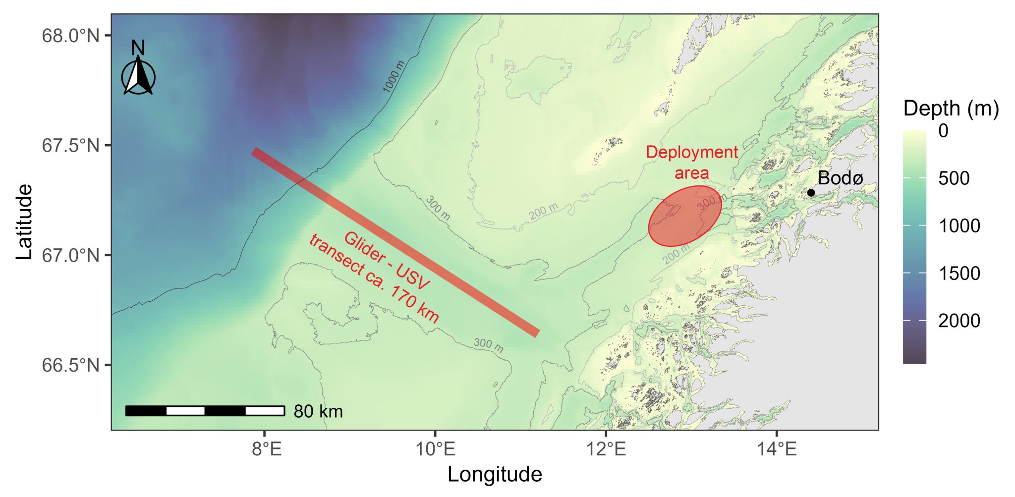
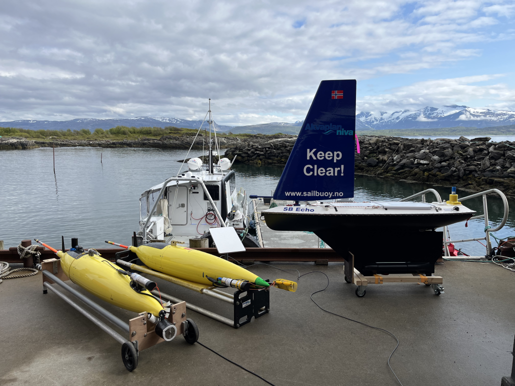
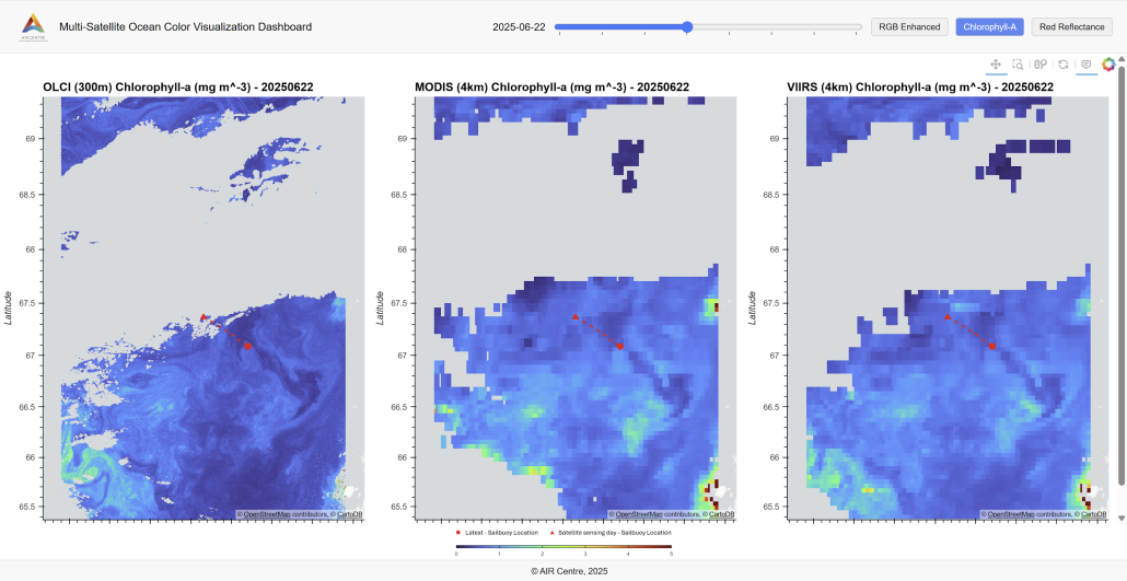
As conventional fisheries face growing challenges from stock depletion, low-trophic fisheries are emerging as a promising pathway for sustainable harvesting. In this context, the numerous and widespread marine copepod Calanus finmarchicus offers an easily accessible lower-trophic-level resource that can be responsibly harvested in the North Atlantic Ocean. In Norway, Calanus fisheries are already established, contributing to the production of natural health oils rich in marine nutrients, as well as high-quality animal feed and sustainable ingredients for aquaculture. These tiny crustaceans, a key component of the marine food web, represent an opportunity for low-impact harvesting. However, as fishing pressure on C. finmarchicus stocks grows, so does the urgency to sustainably manage this blue resource. To address this challenge, the second field campaign of the CliN-BluFeed project was launched on 4 of June 2025 (Figure 1), aiming to improve the understanding and monitoring of C. finmarchicus distributions and dynamics. This second field campaign deployed two autonomous underwater vehicle (AUV) gliders and one unmanned surface vehicle (USV) Sailbuoy (Figure 2), equipped with acoustic and optical sensors, to collect a unique dataset of in situ observations of C. finmarchicus in the Norwegian Sea. The CliN-BluFeed project is funded by Sustainable Blue Economy Partnership (SBEP), an Horizon Europe co-funded partnership, and brings together the Akvaplan-niva, AIR Centre, Cyprus Subsea Consulting and Services, the Institute of Oceanology of the Polish Academy of Sciences (IO PAN) and the Alfred Wegener Institute (AWI). Its main objective is to develop methodologies that advance the Norwegian Sea Calanus fishery as a sustainable resource using autonomous marine monitoring technologies coupled with remote sensing, artificial intelligence, simulation modelling, and experimental investigations. During this second field campaign, the AIR Centre developed the Multi-Satellite Ocean Colour Visualiser (Figure 3), a tool that integrates the Sailbuoy’s real-time position with satellite products such as RGB composites, chlorophyll-a concentration, and red reflectance from different missions (Sentinel-3, MODIS AQUA and VIIRS). This visualiser enables near-real-time (NRT) visualisation and helps guide the autonomous underwater (AUV) and surface vehicles (USV) towards oceanographic features of interest. It also provides large-scale insights into the physical and biological ocean conditions relevant to detecting Calanus swarms. In the coming days and weeks, we eagerly anticipate acquiring various cloud-free satellite images that will enable coincident observations from both satellites and the in situ gliders and Sailbuoy. This will support the development of satellite-based models to improve the detection and monitoring of Calanus swarms that enhance our understanding of the spatial and temporal dynamics of Calanus in the Norwegian Sea and ultimately promote the sustainable harvesting of this vital blue food resource. [caption id="attachment_20373" align="aligncenter" width="800"] Fig. 1 - Second field campaign of the CliN-BluFeed project: deployment locations of the glider and USV off Bodø, with the planned transect within Trænadjupet. Credits: Pierre Priou/Akvaplan-niva.[/caption] [caption id="attachment_20377" align="aligncenter" width="800"] Fig. 2 - The two underwater Seaglider M1 (CSCS SG152 on the left and Akvaplan-niva SG644 on the right) on the left and the USV Sailbuoy at Nord Universitetet, prior to their deployment for the 2025 CliN-BluFeed survey. Credits: Pierre Priou/Akvaplan-niva[/caption] [caption id="attachment_20374" align="aligncenter" width="800"] Fig. 3 - AIR Centre’s Multi-Satellite Ocean Colour Visualiser, showing the sailbuoy’s location (red line) on 22 June 2025 alongside with RGB composites, chlorophyll-a concentration, and red reflectance data from different sensors. Credits: AIR Centre[/caption]
Share this entry

Other News

Event

La Cumbre Científica Portuguesa «Innovación 2026» moviliza a la comunidad investigadora de Portugal en torno a las prioridades futuras

calendar_today July 17, 2026

El Centro AIR participó en la Cumbre Científica Portuguesa «Innovación 2026», celebrada los días 15 y 16 de julio en el Centro de Convenciones de Lisboa, que supuso el primer gran evento organizado por la recién creada Agencia de Investigación e Innovación de Portugal (AI²).

Innovation

Brasil y Portugal refuerzan su cooperación con la inauguración de la oficina de la Fiocruz en Lisboa

calendar_today July 16, 2026

El 15 de julio de 2026, el Centro AIR participó en la visita oficial del ministro de Sanidad de Brasil, Alexandre Padilha, con motivo de la inauguración oficial de la oficina de la Fundação Oswaldo Cruz (Fiocruz) en Lisboa. La nueva oficina está situada en el mismo edificio que alberga también a ApexBrasil, Embratur y Sebrae, lo que refuerza la presencia institucional de Brasil en Portugal y amplía las oportunidades de cooperación bilateral.

Collaboration

Meeting with the Hon Consul‑General of the Kingdom of Tonga strengthens dialogue on ocean science and climate cooperation

calendar_today July 9, 2026

On 2 July, the AIR Centre hosted a meeting at its Lisbon office with the Comendador Anthony Bailey, Honourable Consul-General of His Majesty The King of Tonga to the Portuguese Republic. The discussion brought together AIR Centre Executive Director Miguel Miranda, Deputy Executive Director Mafalda Carapuço, and researcher Ana Faria, marking the beginning of a promising dialogue between the two nations.